

The Hong Kong Observatory issued a high alert – Hurricane Signal No. 10 – just after 9am on Wednesday as typhoon Hato moved closer to the city.
Hato is the first typhoon of that magnitude to hit the city in in five years.
In the coming few hours, Hato will be closest to the territory, skirting about 50 kilometers to the south of Hong Kong.
The Observatory issued a No. 8 Northeast Gale or Storm Signal warning at 5:20am, then upgraded it to an Increasing Gale or Storm Signal No. 9 at 8:10am on Wednesday.
An amber rainstorm warning signal is now on.
The storm is expected to make landfall less than 100 kilometers to the west of Hong Kong in the afternoon, the Observatory said.
Local winds strengthened significantly over the past few hours, with storm-force winds starting to affect offshore waters.
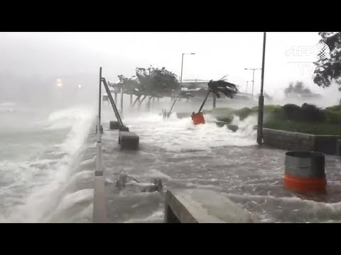
A high water level of three meters or more above chart datum is expected at Quarry Bay on Hong Kong Island between 9am and 2pm, while a high water level of about five meters above chart datum is expected at Tolo Harbor in the New Territories around noon.
There could be severe seawater flooding in low-lying areas, so people have be advised to stay away from the shoreline and stop all outdoor activities.
The MTR Corporation said for safety reasons, rail service in the open or above ground sections of the railway and MTR bus service have been suspended.
A limited rail service in underground sections of the railway will be maintained but travel time may be longer.
The Education Bureau announced that all schools had been closed, while the Social Welfare Department said it had closed all childcare centers, after-school classes, elderly services centers and day rehabilitation units.